


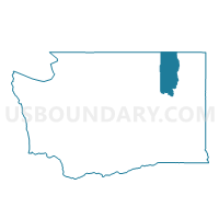
Belcher Voting District, Ferry County, Washington
About
Outline

Summary
| Unique Area Identifier | 684152 |
| Name | Belcher Voting District |
| County | Ferry County |
| State | Washington |
| Area (square miles) | 28.75 |
| Land Area (square miles) | 28.75 |
| Water Area (square miles) | 0.00 |
| % of Land Area | 100.00 |
| % of Water Area | 0.00 |
| Latitude of the Internal Point | 48.71293200 |
| Longtitude of the Internal Point | -118.60383550 |
Maps


Graphs
Select a template below for downloading or customizing gragh for Belcher Voting District, Ferry County, Washington


Neighbors
Neighoring Voting District (by Name) Neighboring Voting District on the Map
- Copper Butte Voting District, Ferry County, WA
- Curlew Kai Voting District, Ferry County, WA
- North Lake Voting District, Ferry County, WA
- Pine Grove Voting District, Ferry County, WA
- Roberta Voting District, Ferry County, WA